")
")
")
From the small car park below the Campliccioli Dam, climb to the departure station of the funicular to Camposecco and from there, continue on flat ground by following the east shore of the lake. Shortly after, you will stumble upon the tracks of the old Decauville railway that was used for the transport of materials when the dam was being built. Once you’ve arrived to the end of the lake, cross the Troncone Creek bridge and start to climb the gentle slope, entering into the valley along the left bank of the water. The torrent of crystal-clear water will accompany you for a long stretch. Pass the pretty clearing of Alpe Casalavera and then continue on into the woods until Alpe Lombraoro. From here, the trail begins to rise sharply: in the first section you will cross a larch forest with a few monumentally sized trees. The climb continues to increase in grade as you reach the ridge and Alpe Saler. Cross the valley along the hillside to arrive to the viewpoint of Alpe Cingino. The dam’s guardhouse is right above your head, but to get there you’ll have to make one last difficult climb, which finishes at Lake Cingino.
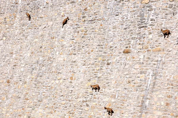
Notes: This trail runs along a part of Via Antronesca, the ancient transit route that connected Ossola to the Saas Valley. It is extremely common to see the spectacular groups of Alpine ibex (also known as steinbock or bouquetin) as they climb the near-vertical walls of the Cingino dam with extraordinary agility, attracted to the saltpetre that the surface exudes. There is a bivouac owned by the CAI Villadossola nearby (tel. +39 0324 575245, www.caivilladossola.net)
Last update: 06/03/2018 ore 15:23:53


